Property Record
Crossgate Rd, Port Wentworth, GA 31407
NEARBY LISTINGS FOR SALE OR LEASE
Property Detail
Crossgate Rd
Savannah, GA
Port Wentworth
7003301004
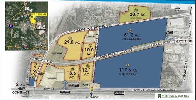
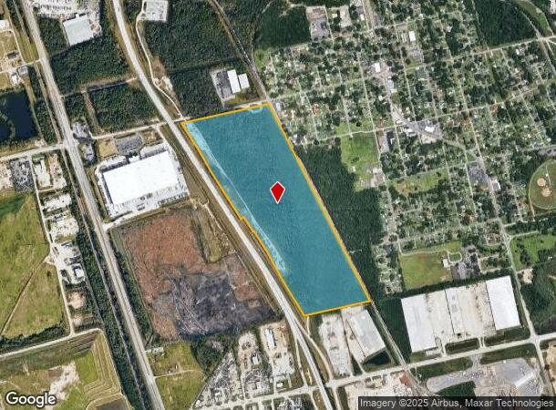
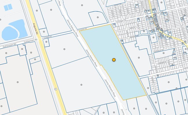
81.27 AC TRACT LOCATED SOUTH OF CROSSGATE RD
Vacantlandnec
Chatham
X
Georgia
45053C0475D
81.27 AC
2024
Port Wentworth
2025
Savannah
010701
DEMOGRAPHICS near Crossgate Rd
1 Mile
3 Mile
5 Mile
2024 Total Population
1,845
6,589
34,878
2029 Population
1,902
6,778
36,783
Pop Growth 2024-2029
+ 3.09%
+ 2.87%
+ 5.46%
Average Age
41
41
37
2024 Total Households
727
2,104
13,392
HH Growth 2024-2029
+ 3.30%
+ 3.14%
+ 5.68%
Median Household Inc
$55,765
$50,306
$63,767
Avg Household Size
2.40
2.50
2.40
2024 Avg HH Vehicles
2.00
2.00
2.00
Median Home Value
$129,861
$143,039
$172,525
Median Year Built
1964
1965
2001
Nearby Places
Map Layers
Map Styles
 Street
 Aerial
- Restaurants
- Banks
- Shops
- Fitness
- Groceries
PUBLIC TRANSPORTATION
COMMUTER RAIL
Savannah (Palmetto - Amtrak, Silver Meteor - Amtrak, Silver Star - Amtrak)
DRIVE
WALK
Distance
Savannah (Palmetto - Amtrak, Silver Meteor - Amtrak, Silver Star - Amtrak)
15 min
7.3 mi
AIRPORT
Savannah/Hilton Head International
DRIVE
WALK
Distance
Savannah/Hilton Head International
14 min
5.6 mi
Hilton Head
DRIVE
WALK
Distance
Hilton Head
55 min
40.7 mi
Freight Ports
Georgia Ports - Savannah
DRIVE
WALK
Distance
Georgia Ports - Savannah
8 min
3.3 mi
SALE & LEASE HISTORY
LISTING DATE
SALE/LEASE

Jun 21, 2017
For Sale
Nearby Properties
Address
Land Use
TOTAL SIZE
Lot Size
Zoning
Address
Land Use
TOTAL SIZE
Lot Size
Zoning
1,008 SF
150 AC
I-H
Address
Land Use
TOTAL SIZE
Lot Size
Zoning
1,400,224 SF
325.62 AC
I-H
Address
Land Use
TOTAL SIZE
Lot Size
Zoning
1,275,180 SF
0.02 AC
Address
Land Use
TOTAL SIZE
Lot Size
Zoning
1,164,800 SF
86.22 AC
Address
Land Use
TOTAL SIZE
Lot Size
Zoning
1,115,200 SF
81.30 AC
Address
Land Use
TOTAL SIZE
Lot Size
Zoning
1,003,267 SF
64.07 AC
I-H
Address
Land Use
TOTAL SIZE
Lot Size
Zoning
588,726 SF
0.30 AC
I-L
Address
Land Use
TOTAL SIZE
Lot Size
Zoning
800,100 SF
44.51 AC
I-H
Address
Land Use
TOTAL SIZE
Lot Size
Zoning
750,480 SF
52.93 AC
IH
Address
Land Use
TOTAL SIZE
Lot Size
Zoning
40,848 SF
19.50 AC
RIN
Address
Land Use
TOTAL SIZE
Lot Size
Zoning
70,000 SF
71.90 AC
IH
Address
Land Use
TOTAL SIZE
Lot Size
Zoning
9,505 SF
0.07 AC
Address
Land Use
TOTAL SIZE
Lot Size
Zoning
285,905 SF
20.16 AC
I-L
Address
Land Use
TOTAL SIZE
Lot Size
Zoning
29.50 AC
IL
Address
Land Use
TOTAL SIZE
Lot Size
Zoning
20,210 SF
85.60 AC
I-H
Address
Land Use
TOTAL SIZE
Lot Size
Zoning
2,156 SF
36.64 AC
PIL
Address
Land Use
TOTAL SIZE
Lot Size
Zoning
515,800 SF
36.16 AC
Address
Land Use
TOTAL SIZE
Lot Size
Zoning
3,648 SF
66.30 AC
I-L
Address
Land Use
TOTAL SIZE
Lot Size
Zoning
408 SF
47.25 AC
I-H
Address
Land Use
TOTAL SIZE
Lot Size
Zoning
600,000 SF
62.25 AC
I-H
Address
Land Use
TOTAL SIZE
Lot Size
Zoning
252,000 SF
31.18 AC
I-H
Address
Land Use
TOTAL SIZE
Lot Size
Zoning
44,940 SF
388 AC
I-H
Address
Land Use
TOTAL SIZE
Lot Size
Zoning
330,900 SF
41.50 AC
I-1
Address
Land Use
TOTAL SIZE
Lot Size
Zoning
420,650 SF
38.65 AC
Address
Land Use
TOTAL SIZE
Lot Size
Zoning
8,100 SF
428.50 AC
I-H
Address
Land Use
TOTAL SIZE
Lot Size
Zoning
10,032 SF
100 AC
I-H
Address
Land Use
TOTAL SIZE
Lot Size
Zoning
392,099 SF
20 AC
I-H
Address
Land Use
TOTAL SIZE
Lot Size
Zoning
391,040 SF
35.39 AC
Address
Land Use
TOTAL SIZE
Lot Size
Zoning
12,150 SF
23.76 AC
Address
Land Use
TOTAL SIZE
Lot Size
Zoning
18,483 SF
71.98 AC
The World's #1 Commercial Real Estate Marketplace
Connect with us
© 2026 CoStar Group
The information above has been obtained from sources believed reliable. While we do not doubt its accuracy we have not verified it and make no guarantee, warranty or representation about it. It is your responsibility to independently confirm its accuracy and completeness. Any projections, opinions, assumptions, or estimates used are for example only and do not represent the current or future performance of the property. The value of this transaction to you depends on tax and other factors which should be evaluated by your tax, financial, and legal advisors. You and your advisors should conduct a careful, independent investigation of the property to determine to your satisfaction the suitability of the property for your needs.